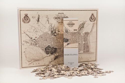


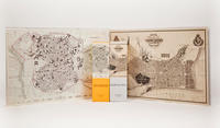
Barcelona Puzzle. Mapa antiguo. 540 piezas (50x35cm)
Architoys
Editorial: Architoys
Referencia: 0806802602677
Edición: 1
Número de páginas: 540
Tamaño: 50 x 35
Aquest pla va ser elaborat el 1859 per l'urbanista Ildefons Cerdà (1815-1876) per a la millora i ampliació de Barcelona. Fins al segle XIX la ciutat havia crescut envoltada per les antigues muralles superpoblada de cases i amb problemes de salut. La densitat de la ciutat era, en aquell moment, una de les més altes d'Europa. Avui encara segueix ben visible l'opció de Cerdà de crear una infraestructura principal per al disseny d'una ciutat confortable amb una gran xarxa de carrers regulars que volia ser la base dun desenvolupament territorial virtualment infinit. Les "cantonades xamfrà", una identitat de Barcelona, han permès a la ciutat créixer durant més dun segle sense canviar el seu caràcter principal. This plan was drawn in 1859 by the city planner Ildefons Cerdà (1815-1876) for the improvement and enlargement of Barcelona. Until the XIX century the growing city was hemmed in by the ancient walls with overcrowded housing and health problems. The city density was, at the time, one of the highest in Europe. Today is still clearly visible the focus that Cerdá given to create the main infrastructure in order to design a wellbeing city whit a large and regular road network which could be at the base of virtually endless territorial development. The chamfered corners, that are typical Barcelona marks, allowed the city growing during more than a century without changing británico que creía en la promoción de la auto-educación y la divulgación del conocimiento para las clases trabajadoras así como para la burguesía que no tenía acceso a experimentados profesores. Las publicaciones de la SDUK trataban, de una manera fácil, temas útiles de historia, geografía o zoología, con el objetivo de apoyar a los iniciados a la lectura y mejorar sus habilidades y conocimientos. Entre varias publicaciones, la SDUK publicó algunos atlas extraordinariamente detallados. En aquel momento no existía nada parecido en ninguna parte del mundo por su calidad y precio. This city map of Madrid was drawn in 1831 by the architect W. B. Clarke for the Society for the Diffusion of Useful Knowledge (UK) and published . on an atlas by Baldwin & Cradock. The SDUK was founded in 1826 by Lord Henry Brougham, a british statesman that believed in the promotion of self-education and the disclosure of the knowledge for the working classes as for the bourgeoisie that could not make use of experienced teachers. The SDUK publications were dealing with useful subjects as history, geography, zoology in an easy way to support those who had just learned to read to improve their reading skills and knowledge. Among several publications, the SDUK published some extraordinarily detailed atlas. At the time there was nothing like that anywhere in the world for its quality and price
Sin stock